

The Blurred Syrian-Turkish Borders in “Upper Jazira” (1920-1929)
By Shoresh Darwish
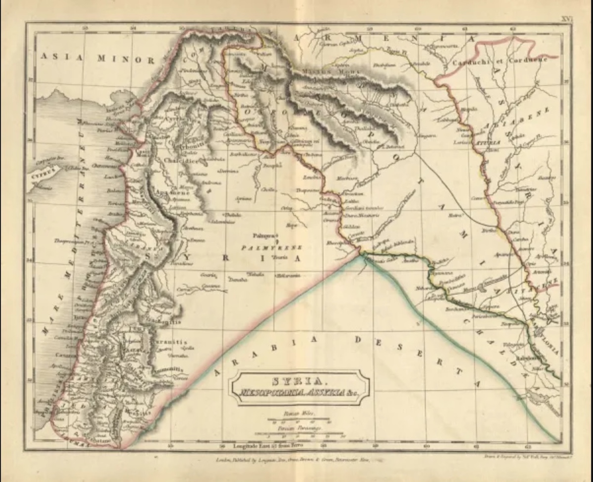
The Sykes-Picot maps (1915-1916), created for the division of the Ottoman Empire, underwent a lengthy process of modifications, such that they no longer resembled their original forms. Among these changes, the “Upper Jazira” area became a focal point for boundary delimitation processes that persisted for nearly a decade following the entry of French forces into Syria. This region did not adhere to a fixed standard in the French projects, which aimed for its autonomy from the rest of Syria due to its Kurdish demographic composition.
The French called it ” Upper Jazira” or, in correspondence from the Secret Service (SR), as “the Duck’s Beak” at the beginning of their mandate, in order to distinguish it from other areas of the Euphrates Basin. In 1926, the French High Commissioner Pierre Alib issued the Administrative Law for the Upper Jazira (Series 304), which defined the territory of this region to include Hasakah and the Khiro district (al-Qamishli).
With the suspension of the Treaty of Sèvres in 1920, due to changes in the military landscape in Anatolia, the aspirations of both Kurdish and Armenian nationalists were dashed. The London Conference on 8 March 1921 ignored Kurdish and Armenian demands. Mustafa Kemal’s military victories over the French in Cilicia prompted France to adopt a less aggressive stance toward the new Turkish leadership, leading to a series of border agreements that began with the 1921 Ankara Agreement, commonly known as the Franklin-Bouillon Agreement, and subsequent agreements that ultimately delineated the Syrian entity, in which the Kurds were incorporated without their consent.
This paper aims to provide an overview of the formation of the Syrian-Turkish border during the third decade of the last century in the Upper Jazira region and the brief period leading up to its demarcation. It explores how the inclusion of Kurdish areas connected to both Northern and Southern Kurdistan into the emerging Syrian entity resulted in ambiguous borders, the issues and duration involved in the border demarcation process, and the direct consequences, such as the establishment of new cities to compensate for the towns and markets lost by the residents of Upper Jazira following the demarcation process.
In interpreting Turkish ambitions within what has become known as the Syrian entity, it is useful to reevaluate the border settlements in the Upper Jazira as constantly subject to adjustments that reflect the direct interests of French and Turkish authorities, rather than the choices of the local population. The primary aim of this paper is not merely to recount history but to illuminate the formation of a portion of Syria that remains subject to the cyclical nature of Turkish ambitions, which have been renewed since 2012 concerning the reclamation of the border area in Jazira.
Furthermore, it examines how history can be seen as ‘repetitive’ according to Ibn Khaldun’s historical perspective, where historical events may recur without necessarily yielding the same outcomes. The reader may notice certain similarities between the nature of Turkish claims in Syria and its desire to modify borders and re-engineer demographics a century ago, and the situations that have developed and begun more than a decade ago. In this context, past French involvement can sometimes be replaced by the roles of the United States or Russia, to grasp the significance of agreements made against the will of the local population, such as the agreement between Washington and Ankara, as well as the one between Ankara and Moscow in the autumn of 2019, which led to the occupation of Ras al-Ayn/Serêkaniyê. This repetition of events over time suggests that the issue transcends the pretext of “national security” to reveal an overwhelming Turkish desire to alter borders and acquire more territory under any guise.
Shortly before the demarcation of borders
Early on, France sought to present its visions for the Kurdish areas of the Upper Jazira. On August 6, 1920, Paris was planning to incorporate Kurdistan into a special project, as indicated in a secret cable sent by French President Alexandre Milleran (1920-1924) entitled “Plan for the Organization of the French Mandate in Syria.” In this cable, he outlines forms of autonomy that could contribute to a “Syrian federation.”
Milleran excluded the “Turkish and Kurdish lands” from the process of establishing Syrian states, asserting that the Kurdish territories “east of the Euphrates, along with Urfa and Mardin… lack any national connection with Syria.” To avoid the establishment of a direct military administration, he suggested that governance should be temporarily entrusted to a Turkish pasha (in Turkish territory), closely monitored. The same approach could be applied to the Kurdish territories.
Milleran proposed a specific individual to govern the Kurdish region, naming “Mehmet Bey,” the leader of the Milli tribe (actually Mahmud Bey, son of Ibrahim Pasha Milli) in Wiran Shahr. He elaborated on his future vision by stating, “The borders should be redrawn so as not to divide the Milli tribe into two parts. Such an agreement with the Kurds and the settlement of Chaldean and Assyrian elements along the railway east of the Euphrates would place us in an ideal political position regarding Kurdistan.” Thus, he advocated for a “cautious penetration of the eastern Euphrates region” in a manner that would enable France to influence this area, as well as Antab, “toward an independent regime or to integrate it into the Syrian federation.” However, he emphasized that “for the time being, a clear distinction must be made between these regions and the Syrian territories” (Kawtharani, 231-232).
It is expected that France adhered to the factional map of Syria’s governance, where the entirety of northern Syria was characterized by ambiguity regarding its governance. After Sharif Hussein’s previous failure to persuade McMahon through the correspondence known as “Hussein-McMahon” about the feasibility of extending Arab rule to the Cilicia region.
The Jazira region, with the exception of Deir al-Zour, was not included in the early Arab nationalist maps. The General Syrian Congress, held on June 7, 1919, delineated its map, which extended only to the western bank of the Euphrates, relying on historical maps of Syria to assert its claim for independence. The conference did not invite any Kurdish figures from the Jazira, Kobani, or Kurdagh regions, and “attendance was limited to Kurdish figures from outside the geography of Syrian Kurdistan” (Mirani 24).
Shedding light on the early stages of Syria’s formation helps explain part of the delayed integration of the Kurds and their geography into the Syrian state.
Of course, the dynamics of the conflict were different from what Milleran, who was not as realistic as his predecessor Clemenceau, envisioned. The new president authorized his general, Gouraud, to take “any measures necessary to maintain security, defend the people, and ensure the protection of the armies,” believing he possessed “the means to enforce respect for our rights” (Barr, 117). However, Gouraud did not have sufficient troops to establish order, including curbing Turkey’s ambitions. Additionally, suppressing Arab opposition required reaching an agreement with Mustafa Kemal, and he needed British support.
It is important to note that the Kurdish-Turkish issue had not yet erupted during Mustafa Kemal’s War of Independence, despite the failure to implement the provisions of the Sèvres Agreement. In fact, Kemal himself requested that the conditions in the Kurdish regions be considered, as he sought to present himself “as the protector of the caliphate,” given that the Kurds were connected to the Ottoman state through the caliphate, and many Kurdish factions were apprehensive about Armenian aspirations. In this tense climate, Mustafa Kemal issued orders in June 1920 to Nihat Pasha Anilmesh, commander of the Jazira Front on the French-protected Syrian border, instructing him to “gradually hand over the areas inhabited by Kurds to a local government, as this would serve our internal and external policy interests” (Atatürk 220).
In practice, Mustafa Kemal’s policy between 1919 and 1923 was not decisively anti-Kurdish. The Amasya Protocol, along with his letters to Kurdish aghas and sheikhs and the speeches of the President, kept the door open for local autonomy in various Kurdish regions (Gorgas 25). However, for the Kemalists, the border conflict followed dynamics that were different from whether a Kurdish-Turkish conflict existed or not; Turkey’s goal of controlling the route to Mosul through the Upper Jazira was paramount.
Turkish officer Ismail Hakki Gündez played a significant role for years in hindering the French occupation of the entire Upper Jazira, utilizing both Kurdish and Turkish tribes. This strategy delayed French control of Hasaka until May 1922, a year after the demarcation of the Syrian-Turkish border (the Ankara Agreement). The process of stabilizing the border did not prevent Gündez from imposing taxes on some villages in the Upper Jazira. Additionally, France accused Ismail Hakki of instigating the Bayandour incidents in 1923, when clashes erupted between the local Kurdish population and French military authorities. This prompted General Pigou to storm the Bayandour base, described as “the refuge of Ismail Hakki, who had already begun seeking support among the Kurdish tribes surrounding the Upper Jazira. Among the candidates for the Turkish commander’s assistance, Hajo Agha epitomized the ideal image of an ambitious leader ready to embark on military adventures once more” (Gorgas 57).
Between 1922 and 1924, French forces faced 381 military operations, while the commander of the French army in northern Syria, General Biot, attempted to avoid conflict with the Kurdish clans in the Jazira (Barout 157). Among Biot’s measures were appeasing tribal leaders by appointing them as district administrators and addressing their claims regarding agricultural lands in Turkey, medical care in the region, and other developmental issues.
Indeed, Mosul was the focal point of Turkey’s initial border movements in the “Duck’s Bill” area, as the success of Lloyd George, the British Prime Minister who dreamed of dismantling the Ottoman Empire, in wresting Mosul from French President Clemenceau after the discovery of oil in the province (Bar 77), heightened Turkish fears regarding its fate. Consequently, the Turks intensified their efforts in the border region, whether through the policy of border agreements with France or by manipulating the tribal structure and inciting Arab and Kurdish tribes against the French themselves. The Ankara Agreement became the crown jewel of these agreements, which France found advantageous in preventing the Turks from opening a second front across the eastern Euphrates.
Blurred Borders
The northern borders of Syria have long been blurred and a subject of political debate. In the Hussein-McMahon correspondence, Sharif Hussein indicated that the borders of the Arab state should extend to Mersin and Adana, meaning up to the 37th parallel north, “so that Iskenderun and Antakya would become part of the desired Arab state.” However, Henry McMahon insisted in a private letter that “the inhabitants of these areas are not pure Arabs.” Sharif Hussein maintained that they were indeed Arab. Ultimately, the latter agreed to cede only Mersin and Adana (Khadduri 5). Thus, the Syrian-Turkish border remained undefined despite the insistence or leniency in those communications. Notably, the annexation of Iskenderun and Antakya more than two decades later demonstrated that the Turks were capable of repeatedly altering their southern borders.
In addition to Turkish ambitions, there were other reasons stemming from the fragility and limited understanding of state geography. Consequently, borders were of little importance; what truly mattered was governance and power, rather than geography. It is important to note that the northern provinces of Syria were not under any particular stable authority. Some Syrians later fought against France under Syrian leadership and with an Ottoman/Turkish flag, as was the case with Ibrahim Hanano and others, while some fought alongside Mustafa Kemal in the ‘War of Independence’ from 1919 to 1923 (Aqeel 24). Furthermore, Hanano entered into an agreement with Salah al-Din Adil, the commander of the Turkish army in Maraş, on September 6, 1920, stipulating that “no border between Syria and Turkey shall be defined until after the enemy has been expelled from their territories and they have secured full independence” (Aqeel 34). This agreement took place about a year prior to the Turks defining the borders with the French in Ankara, during which the Turks did not honor their commitment to Hanano.
Could it be argued that there was a Turkish deception of Hanano and the other Syrians who fought alongside the Turks? Or was the dream of restoring the caliphate the bond that connected Syrians and Turks before the declaration of the Turkish Republic? This argument may appear somewhat weak, as the relationship persisted during the period of the Great Syrian Revolution (1925-1927). However, the enduring relationship can be understood in light of a shared interest in expelling the French, even after the northern border was demarcated in favor of Turkey, without a return to its Syrian ‘allies.’
As for the obstacles to the demarcation process, according to Christian Fludd, they were tied to Turkey’s and Iraq’s enduring territorial ambitions. The ambiguous status of the Duckbill region, which was not part of Syria and was geographically and especially economically distant from the major urban centers in Syria (Gorgas 67), aligns closely with Melran’s earlier perspective on the nature of the eastern Euphrates and Jazira regions. This ambiguity complicated efforts by the Turks and the French to reach a satisfactory and final agreement on the borders in the “Upper Jazira,” as we shall see. In other words, the French vision of integrating Kurdish geography into mandatory Syria had not yet fully crystallized.
The Ankara Agreements and the Delayed Border Stabilization
Article 1 of the Ankara Agreement officially ended the war between France and the Kemalists on October 20, 1921, following negotiations that began in March of the same year. France was compelled to cede nearly half of its territorial gains in Kurdistan to the newly established Turkey. The Ankara Agreement (the Franklin-Bouillon Agreement) effectively rendered the Treaty of Sèvres obsolete and altered the trajectory of the Sykes-Picot Agreement, thereby annexing parts of the Kurdish regions to the new Syrian entity. Under this agreement, France relinquished a total of 18,000 square kilometers of territory that had been allocated to Syria according to the Treaty of Sèvres: Cilicia and the eastern region, which included Antep, Maraş, Urfa, Kilis, Diyarbakir, Mardin, and the upper areas of the Botan region, while Jazira, Jarablus, Kobani, and Afrin remained under French administration.
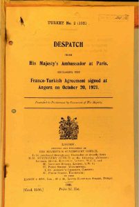
The agreement was deemed a triumph for the Kemalists and represented a significant setback for Britain, which had sought to undermine them. Britain opposed the Ankara Agreement from a strategic standpoint, as granting Nusaybin and Botan Island to Turkey would provide the Kemalists with an advantageous position for launching attacks on Iraq (Barout 175). Additionally, the agreement diminished France’s standing in Syria (Khadduri 9). Nonetheless, it did not resolve the issue of international borders definitively; rather, it resembled a fragile truce that could be breached and manipulated. Turkish bands were also conducting raids along the Syrian border despite the Ankara Agreement, the subsequent Mudanya truce on October 11, 1922, and the signing of the final peace treaty with the Allies under the Treaty of Lausanne on July 24, 1923. These movements and particularly the guerrilla raids intensified in early 1924. To address this security turmoil, border demarcation committees were established in accordance with Article 8 of the first Ankara Agreement.
In practice, the demarcation process was renewed due to violations and the inability of both parties to control them. On May 30, 1926, a new agreement, known as the De Jouvenel Agreement, was signed by the French High Commissioner to Syria. While France fulfilled its commitments, the Turkish side did not adhere to the obligations established by the first Ankara Agreement. The dispute over the island reignited through an analysis of the content of Article 8, which was demarcated as follows: the border starts from the coastal city of Bayas, then extends eastward, passing through Kilis to reach the Çuban Bey station, continuing through Nusaybin and following the ‘ancient Roman road’ to the island of Botan, where it meets the Tigris River. Nusaybin and Botan remained part of Turkey, but both countries were entitled to use this route. However, a disagreement arose regarding the definitions of the old route. Consequently, the demarcation of the border was delayed due to issues within the Turkish-French commission.
The Turkish demands focused on claiming several centers south of the Franklin-Bouillon line, such as the Bayas railway, some Arab villages affiliated with the Turkish city of Kilis, and parts along the eastern border. This is where the obstruction of the committee’s work began. While France was in a difficult situation, with a Syrian revolution erupting between 1925 and 1927, de Jouvenel believed that resolving the issue diplomatically was the best approach. Therefore, on February 18, he signed an agreement with Turkish Foreign Minister Tawfiq Rushdi Aras, which became known by his name, along with five protocols. Among the agreements reached were measures for combating gangs in the border area, which was set at 50 kilometers from either side of the Syrian-Turkish border, and provisions for the exchange of criminals according to the additional protocol. To alleviate the burden of Article 8, a new commission was established under Article 2 of the new treaty. This commission commenced its work in 1926 and completed the delimitation of the border, except for Nusaybin and Botan Island. The commission had to locate traces of the ancient Roman road, which had been neglected since the fall of the Abbasid state, and the neutral head of the commission, Danish General Ernst, leaned towards the French perspective. The dispute persisted until 1928 due to the stubbornness of the Turkish side, during which time there were some raids by Kurdish gangs along the Turkish border (Khadduri 18). However, in 1929, the boundary issue was resolved concerning the Upper Jazira, with the Turks receiving one-fifth and Syria four-fifths. By 1930, Syria restored the territory that had been occupied by Turkish forces, which had laid claim to it.
The year 1929 marked another turning point as negotiations resumed following repeated attempts by the Turkish ambassador in Paris to persuade the French foreign minister to establish a new border line further south “in order to annex around 80 villages that Ankara considers a refuge for gangs operating in Turkey” (Gorgas 71). Negotiations resumed based on Turkish proposals, and a new pact was reached in June 1929 that detailed the border line between Nusaybin and Botan Island. Consequently, the border was moved south by 5 kilometers at Tel Hassan in the Hverkan clan area and by 500 meters in the Botan Island area.
In effect, France acquired 85 villages allowing access to the Tigris River in exchange for ceding 80 Kurdish villages to Turkey. Behind the scenes, however, Turkey sought significant benefits, such as the gains for the Bozanti, Aleppo-Nusaybin railway company (Gorgas 72).
In reality, it took nearly six years, along with a subsequent period, totaling ten years of agreements, disagreements, and violations, to finalize the borders of the Upper Jazira. During this time, the Turks capitalized on their advanced local expertise. For example, France’s cession of Nusaybin was a result of its delayed realization that it lay two kilometers south of the railway and thus should be part of Syria, but the Ankara Agreement stipulated that it would be ceded to Turkey.
The issue did not stop at Nusaybin. Following the loss of Mosul and the 1925 uprising of Sheikh Said Biran, the Turkish desire to control the ‘Upper Jazira’ became more pronounced. The loss of the Kurdish-majority province of Mosul raised concerns in Turkey about the possibility of losing additional Kurdish territories, while “Sheikh Said’s uprising heightened the fears of the Turkish government, which believed that Britain had provided some support to the Kurdish rebels” (Gorgas 70).
In light of this, the French High Commission viewed the situation as favorable to them, even though they felt deceived regarding Nusaybin. “Although the border was not precisely defined on the Nusaybin side, it allowed Kurdish dissidents to exploit this ambiguity to seek refuge from persecution and prepare for incursions into Turkish territory.” Consequently, France offered the Turks a kind of “safe zone” within Syrian territory: “We requested our neighbors (the Turks) to occupy the area that belongs to us so that we could provide them with security and protection from the consequences of Kurdish hostility toward them in this region” (Gorgas 71). This pattern of agreements and understandings with a security focus served as an additional indicator of France’s frequent inaction in the face of Turkish violations, including the occupation of Kurdish territories that had become part of Syria.
It is notable that the years of border turmoil were marked by Turkish ambitions and various pretexts for border incursions, whether by inciting Arab and Kurdish tribes against the French to push them back at the onset of their occupation of the ‘Upper Jazira’ or by claiming to act against “Kurdish gangs,” or establishing “safe zones” within Syrian territory, especially after the Sheikh Said uprising in 1925. The agreements allowed each party to operate 50 kilometers into the other’s territory. The most crucial observation is Turkey’s tenacity in amending the borders and seizing kilometers, and sometimes just a few hundred meters, within what became known as the Syrian state. Not to be overlooked in the border demarcation process is the adeptness of both Turkish and French parties in utilizing the Kurdish card to their advantage.
Creating Cities: France’s Revenge
With the loss of cities that served as commercial centers for the population, particularly Nusaybin, Mardin, and other cities that fell behind the Turkish border, France faced the necessity of urbanizing the region by establishing new cities. For instance, Al-Qamishli was selected to serve as a commercial and administrative center equivalent to its counterpart, Nusaybin. The French dedicated significant efforts to transform this city, founded in 1923, into a functional urban center. This transformation included constructing military barracks and administrative offices, beginning on August 20, 1926 (Cherfani 40).
Similarly, Al-Hasakah was developed on the site of an Ottoman military barrack. The city was established in 1900 when the Ottoman government appointed Fawzi Bey as commander of the Badia forces, subsequently building his first outpost on the Khabur River. Population influx began in 1912 (Sharafani 40). However, Hasakah did not emerge as a true city until 1922, When military organization efforts commenced for urban development, urban centers in the region originally developed around military barracks. The architectural style reflected their military origins, as intelligence officers were responsible for drafting and implementing the foundational urban plans for cities like Al-Hasakah and Al-Qamishli.
It’s important to emphasize that the establishment of these cities was not arbitrary; it was driven by specific objectives. This included the creation or designation of cities as district centers adjacent to the railway—such as Derbasiya, Amouda, and Ras al-Ayn/Serê Kaniyê—intended to undermine Turkish-controlled cities like Qamishli and Ain Dewar. Some cities were built for “strategic distance,” such as Hasakah and Derek, serving as fallback locations for security (Gorgas 92-93).
In practice, urbanization efforts focused on creating markets to meet the needs of the rural population, supporting reconstruction, enforcing security, and compensating for the cities that Turkey had seized.
Upon closer examination, it becomes evident that the establishment of these cities negatively impacted the economic conditions of Turkish cities, such as Nusaybin and the island of Botan, leading to a decline in their significance as urban centers serving dozens of villages located south of the railway line. The construction of these new cities also facilitated the emergence of a class of “notables,” bringing together tribal leaders and educated individuals in a more urban environment. This reconfiguration led to the establishment of new centers of political opposition to Turkey. These political figures gained prominence in the mid-1930s through the autonomy movement in the region, led by Kurdish notables, intellectuals, educated individuals, Christian bishops, and some Arab tribal sheikhs.
Subsequently, the mandate’s military succeeded in sustaining the cities and mitigating the adverse effects of border demarcation on the population. Despite episodes of poverty and deteriorating living conditions, particularly between 1930 and 1933, French settlement policies effectively revitalized the “Upper Jazira,” an effort that had previously failed under the Ottoman state and its revival projects. The Kurds had highlighted the economic importance of this region, with the Ottoman newspaper Kurd referring to it as “Ottoman America” in 1908, a sentiment echoed by Western newspapers calling it the “California of the East.” Regardless of the terminology used to underscore the economic significance of this region, the complex and challenging process of border demarcation ultimately contributed—after the stabilization of cities and borders—to increasing aspirations for both Syrian and Turkish nationalism. This situation leveraged the Kurdish identity of the border areas as a pretext for both sides to implement policies that negatively impacted the local population and undermined their political and cultural choices.
References
Collection of Government Resolutions of Syria. Sader Press, Beirut, 1933.
Wajih Kawtharani. The Levant at the Turn of the Twentieth Century. Arab Centre for Research and Policy Studies, 3rd edition, Beirut, 2013.
Ali Saleh Mirani. The Kurdish National Movement in Kurdistan-Syria. Dohuk, 2004.
James Barr. A Line in the Sand. Dar al-Saqi, Beirut, 2018.
Klaus Kreiser. Atatürk (A Biography). Arab Centre for Research and Policy Studies, Beirut, 2023.
Jordi Gorgas. The Turkish Kurdish Movement in Exile. Al-Farabi Aras, Beirut, 2013.
Majid Khadduri. The Iskenderun Affair. The Great Library for Authorship and Publishing, Damascus, 1953.
Aqeel Said Mahfoudh. Parallel Maps: A Study. Damascus Centre for Research and Studies, 2016.
Mohammad Jamal Barout. The Modern Historical Formation of the Syrian Peninsula. Beirut, 2013.
Burhan Najmuddin Sharafani. Syrian Kurdistan During the French Mandate. Dar al-Zaman, 2018.

Comments are closed.